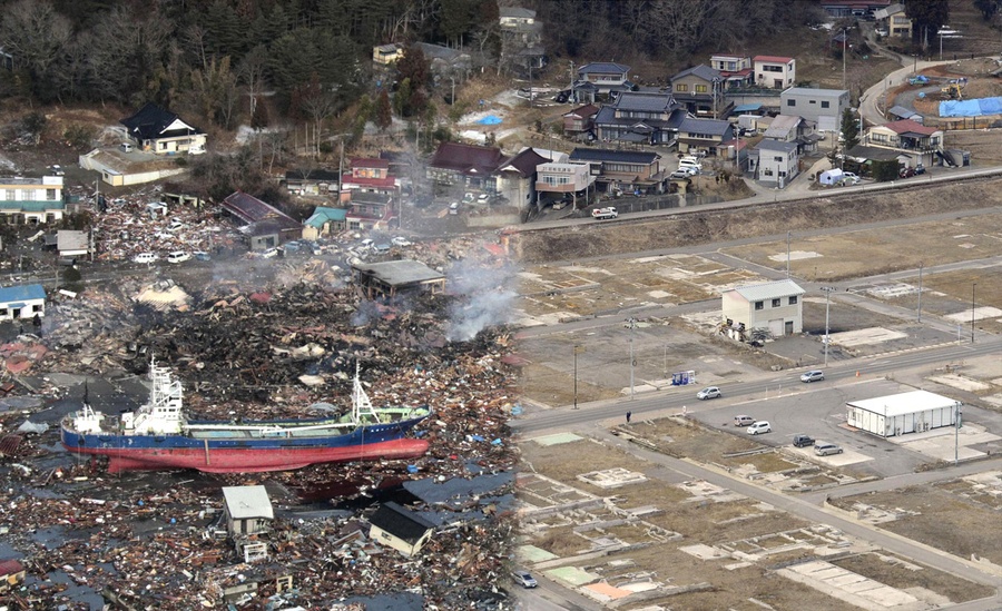
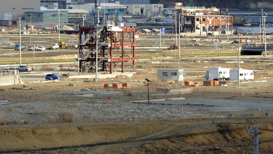
Japan before and after the devastated the Tohoku tsunami and earthquake
اليابان قبل وبعد زلزال وتسونامي توهوكو المدمر
مارس 2016 يصادف الذكرى السنوية الخامسة من زلزال اليابان وتسونامي توهوكو ، والذي تسبب في كارثة فوكوشيما النووية، حيث أدى ذلك إلى سلسلة من الانفجارات في محطة الطاقة النووية التي كانت هي الأكبر منذ كارثة تشيرنوبيل.

The tsunami-devastated Kesennuma in Miyagi prefecture, is pictured in this side-by-side comparison photo taken March 12, 2011 (left) and March 4, 2013 (right), ahead of the two-year anniversary of the March 11 earthquake and tsunami that damaged so much of northeastern Japan.

Tsunami debris covers a large area of Natori, near Sendai in Miyagi prefecture on March 13, 2011, and the same field on February 21, 2013.
In a few days, Japan will mark the 2nd anniversary of the devastating Tohoku earthquake and resulting tsunami. The disaster killed nearly 19,000 across Japan, leveling entire coastal villages. Now, nearly all the rubble has been removed, or stacked neatly, but reconstruction on higher ground is lagging, as government red tape has slowed recovery efforts. Locals living in temporary housing are frustrated, and still haunted by the horrific event, some displaying signs of post-traumatic stress disorder. Collected below are a series of before-and-after interactive images. see the image fade from before (2011) to after (2013).

سلسلة الأحداث المدمرة هذه أدت إلى مقتل 18,000 شخصاً، ونحو 300,000 شخص تم اجلاؤهم من المنطقة المحيطة لمحطة فوكوشيما دايتشي. هنا مجموعة من الصور قبل وبعد للمنطقة المتضررة. وقد تم التقاط هذه الصور بعد وقت قصير من وقوع الزلزال، في حين أن الصور الأخرى تم التقاطها في الآونة الأخيرة، بعد خمسة سنوات من التنظيف.

This before-after pair of images shows a private plane, cars and debris outside Sendai Airport in Natori, Miyagi prefecture on March 13, 2011, and the same area two years later, on February 21, 2013.
في 11 مارس 2011، بدأ الزلزال في الساعة 02:46 بالتوقيت المحلي. وقد دُمّرت مدينة كيسينوما تماماً من جراء الكارثة. وقد أدى ذلك إلى جلب العديد من قوارب الصيد الكبيرة إلى الشاطيء.

وفى خلال أقل من ساعة كانت كافية لهذا الزلزال بأن يدمر الساحل.

كانت مدينة ناتوري في مياجي واحدة من المدن الأكثر تضرراً. على الرغم من أن العلماء اليابانيين توقعوا بحدوث الزلزال بشكل أصغر، ولكنه خالف جميع التوقعات.
![]()

A tsunami-hit area of Rikuzentakata, Iwate prefecture on March 29, 2011, and the same area on February 19, 2013.

عانت مدينة ريكوزينتاكا، إيواته في محافظة ايواتي، من ارتفاع الأمواج لمسافة 42 قدماً (12.8 متراً)، مما أدى إلى قتل 1700 شخصاً.
![]()

The tsunami-devastated Minamisanriku, Miyagi prefecture, seen on March 13, 2011, and March 2, 2013

في بعض الأماكن، وصل ارتفاع الأمواج إلى 128 قدم (39 متراً).
![]()

Residents walk past damaged cars on a street in a tsunami-damaged area of Tagajo, Miyagi prefecture on March 13, 2011, and the same street on February 21, 2013.

تعرضت بلدة Narahaبشدة من الكارثة النووية في فوكوشيما دايتشي. ما بين 12 و 15 مارس 2011، وقعت ثلاثة انفجارات نووية كبيرة في الموقعكما تسبب هذا الزلزال في فشل نظام التبريد في المصنع.

A catamaran sightseeing boat washed by the tsunami onto a two-story tourist home in Otsuchi, Iwate prefecture on April 16, 2011, and (click to fade) the same area on February 18, 2013.
في عام 2015، ذكرت أسوشيتد برس أنه لم يكن هناك سوى بضع مئات من الأشخاص الذين عادوا إلى Naraha. وبحلول ذلك الوقت، صرفت الحكومة ما يقرب من 13.5 مليار دولار على عمليات إزالة التلوث – ولا يزال هناك الكثير مما ينبغي القيام به.

Residents crossing a bridge covered with debris in a tsunami-hit area of the city of Ishinomaki in Miyagi prefecture on March 15, 2011, and (click to fade) the same area nearly two years later on February 22, 2013

العاصفة دمرت الحواجز البحرية المبنية على بعض أجزاء من الساحل. على الرغم من أن محطة الطاقة النووية في أوناجاوا كان لديها سور بحري واقي بارتفاع 46 قدم، إلا أنه لم يمنع الفيضانات الشديدة.

Residents look at a tsunami-damaged area of Minamisoma, Fukushima Prefecture, on March 12, 2011, and (click to fade) the same area on February 17, 2013.

في عام 2013، ذكرت محطة طوكيو للطاقة الكهربائية أن حوالي 300 طن من المياه المشعة تتسرب في المحيط الهادئ كل يوم.

Rusted vehicles and tsunami debris in Ishinomaki, Miyagi prefecture, on March 19, 2011, and March 1, 2013.

كان لزلزال وتسونامي توهوكو تأثيراً في جميع أنحاء العالم، بما في ذلك كسر الجبال الجليدية قبالة جرف سولزبيرغر الجليدي في القارة القطبية الجنوبية، والتسبب في وصول موجات كبيرة إلى ألاسكا وهاواي وتشيلي. لا يزال تأثير الكارثة دائم حتى اليوم، بعد خمسة سنوات.
![]()

A tsunami-hit street in Ofunato, Iwate prefecture on March 14, 2011, and the same scene as it appeared on February 19, 2013


A rescue worker walks through rubble in the tsunami hit area of Minamisanriku, Miyagi prefecture on March 18, 2011, and the same area on February 20, 2013.

A cherry blossom tree stands among tsunami debris in the city of Kamaishi, Iwate prefecture on April 20, 2011, and the same scene on February 18, 2013

A catamaran sightseeing boat washed by the tsunami onto a two-story home in Otsuchi, Iwate prefecture on April 16, 2011, and the same structure on February 18, 2013

On March 12, 2011, people evacuate down a road flooded by the tsunami in the city of Ishinomaki in Miyagi prefecture, click to fade the image and show the same road on February 22, 2013.

On March 12, 2011, people evacuate down a road flooded by the tsunami in the city of Ishinomaki in Miyagi prefecture, and show the same road on February 22, 2013.


A 10-meter tall pine tree stands in Rikuzentakata, Iwate prefecture on March 29, 2011, shortly after the tsunami. the same scene nearly two years later, on February 19, 2013. It was the only tree to have survived the tsunami among some 70,000 trees located by the seashore to protect from salt, sand and wind damage, but later died. The crane (2nd image) is working on a memorial to the tree.


Tsunami-hit Ofunato, in Iwate prefecture on March 14, 2011, and the same scene as it appeared on February 18, 2013.


An image of the tsunami breaching an embankment and flowing into the city of Miyako, Iwate prefecture, taken by a Miyako City official on March 11, 2011, and the same scene on February 18, 2013, nearly two years later.


